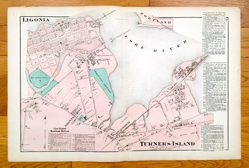


Antique 1871 Cape Elizabeth, Maine Map from F.W. Beers Atlas of Cumberland County – Portland, top Ligonia, Turner's Island, Browns Hill, Fore ME
Beautiful, antique map of the northern section of Cape Elizabeth, Maine, including Ligonia, Browns Hill and Turner's Island. This is an authentic map taken from F.W. Beer's Atlas of Cumberland top County published in 1871 and NOT a computer reproduction.
See what Maine looked like more than 145 years ago. Lots of charming, intricate details and contours, including main roads, hills, rivers, ponds, houses, a business directory and the names of property owners at the time. Hand colored. Verso is blank.
Perfect for the historian, map-lover, the curious or just as a conversation starter. Wonderful and rare. Vintage maps such as these make great gifts.
Edition of 1871, printed 1871
Dimensions: 23" width x 15 1/2" height
----
Cities, Villages & Points of Interest: Cumberland County, Cape Elizabeth, Ligonia, Brown's Hill, Turner's Island, Cape Elizabeth Depot, Portland, Fore River, Cumberland Bone Company, Vaughns Bridge, Portland Rolling Mills, Cape Elizabeth Business Notices and property owners' names.
Condition: Good Vintage condition, commensurate with age. This map is in incredible shape for being almost 150 years old. Light edge-wear, but this will read as vintage character when framed.
(Picture of cover of the atlas is for reference and not included.)
----
We will happily adjust shipping price for multiple purchases. Maps are rolled up and shipped in sturdy mailing tubes, never folded.